Trail Horseback riding La Tieule - Etoile La Tieule par Rouge Parets - Photo

Etoile La Tieule par Rouge Parets

© OpenStreetMap contributors
Length
Length
26 km
Max alt
Max alt
956 m
Uphill gradient
Uphill gradient
728 m
Km-Effort
Km-Effort  
36 km
Min alt
Min alt
770 m
Downhill gradient
Downhill gradient
738 m
Boucle
Boucle
Yes
Creation date :
2021-01-15 15:23:09.161
Updated on :
2021-01-15 15:23:59.451

(0 Reviews)

Horseback riding
Horseback riding
4h45
Difficulty : Difficult

Scan this QR Code to open this trail in the SityTrail application

FREE GPS app for hiking

Logo SityTrail SityTrail

IGN / Geographical institutes

Download SityTrail from the App Store Download SityTrail from Google Play

Logo SityTrail SityTrail World

The world is yours!

Download SityTrail from the App Store Download SityTrail from Google Play Download SityTrail on Huawei AppGallery

About

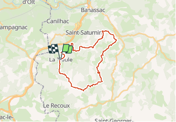
Trail Horseback riding of 26 km to be discovered at Occitania, Lozère, La Tieule. This trail is proposed by Lozère Cheval.

Description

La Tieule en passant par Mas de Donat, Rouget Parets, Gauzines, Maynard, Betones, Esquino d'Aze Retour La Tieule

Elevation profile

Positioning

Country:
France
Region :
Occitania
Department/Province :
Lozère
Municipality :
La Tieule
Location:
Unknown
Start:(UTM)
512443 ; 4914570 (31T) N.

Trails nearby

Trail Walking La Canourgue - Dessus la canourgue - Photo
Walking
peillo

Walking

Difficult
La Canourgue, Occitania, Lozère, France
9.1 km | 14.4 km-effort
3h 48min
No
Trail Walking Saint-Saturnin - Vers l'antenne de La Canourgue - Photo
Walking
Alain-49

Walking

Easy
Saint-Saturnin, Occitania, Lozère, France
6.9 km | 8.8 km-effort
1h 42min
Yes
Trail Horseback riding La Tieule - La Tieule - Etoile par Le Maynard - Photo
Horseback riding
Lozère Cheval

Horseback riding

Difficult
La Tieule, Occitania, Lozère, France
27 km | 37 km-effort
4h 53min
Yes
Trail Horseback riding La Tieule - Etoile de Coustaraços ( La Tieule par Meynard et Pertuzades) - Photo
Horseback riding
Lozère Cheval

Horseback riding

Very difficult
La Tieule, Occitania, Lozère, France
29 km | 42 km-effort
5h 33min
Yes
Trail Walking La Tieule - Chemin de St Guilhem - La Tieule - Saint Georges de Lévéjac - Photo
Walking
GUIDE
Kargil

Walking

Very difficult
La Tieule, Occitania, Lozère, France
21 km | 28 km-effort
5h 56min
No
Trail Horseback riding La Tieule - Grande Boucle Tieule/Canourgue/Champerboux/StEnimie/MasRouch/Tieule - Photo
Horseback riding
Lozère Cheval

Horseback riding

Very difficult
La Tieule, Occitania, Lozère, France
91 km | 123 km-effort
15h 4min
Yes
Trail Horseback riding La Tieule - Boucle  La Canourgue/ La Tieule / Mas Rouch  - Photo
Horseback riding
Lozère Cheval

Horseback riding

Very easy
La Tieule, Occitania, Lozère, France
66 km | 91 km-effort
Unknown
Yes
Trail Walking Campagnac - Campagnac - Photo
Walking
denis48230

Walking

Very easy
Campagnac, Occitania, Aveyron, France
14 km | 17.9 km-effort
5h 52min
Yes
Trail Walking La Canourgue - Roqueprins La Canourgue - Photo
Walking
micmouren

Walking

Easy
La Canourgue, Occitania, Lozère, France
4.1 km | 7.9 km-effort
54min
Yes


Close
My subscriptions